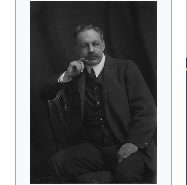
Photo:
Halford John Mackinder
Director of LSE 1903-1908 ‘He taught geography at the School from 1895; had taught at Oxford and has been Principal of University College, Reading. He resigned the LSE Directorship in 1908 to contest a bye-election (as a Liberal Unionist) which he lost, but was elected to Parliament for the Camlachie Division of Glasgow in 1910 and held the seat until 1922. During this period he remained on the academic staff as a Reader in Economic Geography, and later Professor, until his retirement in 1925. He died in 1947.’ LSE Magazine, November 1983, No66, p.18 Excerpt from reminiscences of former staff. ‘LSE Material on the history of the School’ LSE Archives ref R(S.R)1101 : Sidney Webb on Halford Mackinder, p.16 ‘He was a magnificent lecturer; he was an admirable person – he kept the place going with one little finger.’ Miss Mactaggart (Director’s Secretary) on Halford Mackinder, p.67 ‘He had an enormous grip on things. He had never had justice done to him; he did not leave any kind of popularity behind him. This was perhaps due to the fact that he was a very shy man: he used to dash up the stairs and never look at anybody…He was difficult to work for – but really splendid to work with.’ Alice T. Bottomley (Student 1904-08), Demonstrator in Geography 1908-12 on Halford MacKinder, pp.153-4 To me the most inspiring lecturer was Mr Mackinder. As he talked you could see by the movements of his hands that he was visualising the natural forces at work on the area and the shapes on which they worked. Modern geography may be said to date from the work of Mr Mackinder and Prof. Herbertson at Oxford, and we students of geography felt greatly privileged to be in at the new birth. In my fourth year I studied geography under Mr Mackinder and he then appointed me Demonstrator in Geography (part time) and the first such appointment at the School. My duties were mainly in map room with the map class students, but later I gave a few lectures. Mr Mackinder and Prof. Sargent designed special desks and map drawers and cupboards for map work and maps, and part of my work was to make maps for special purposes. For more information on Halford Mackinder visit: www.lse.ac.uk/collections/mackinderProgramme/pdf/mackinde… IMAGELIBRARY/117 Persistent URL: archives.lse.ac.uk/dserve.exe?dsqServer=lib-4.lse.ac.uk&a…
“…In the last 10,000 years, the world’s most developed societies have almost always been in the band of latitudes that Mackinder called Eurasia’s “inner rim,” running from the Mediterranean to China. Farming was invented in this area, with the Middle East leading the way around 9500 B.C. and the rest of the inner rim following its example over the next several thousand years. Along with farming came cities and governments, which most parts of the inner rim had developed by 500 B.C. Two hundred and fifty years later, the world’s first multiethnic empires comprising tens of millions of subjects controlled most of the inner rim.
Because ancient empires could not project their power very far, at any one time the inner rim tended to have four or five regional hegemons, jostling with each other but rarely extending their power into what Mackinder called Eurasia’s “outer rim,” facing toward the oceans, or its “heartland,” far from the seas. However, because Eurasia’s inner rim held 75 percent of the world’s population and 90 percent of its wealth, its imperial rivalries became the most significant issues in global geopolitics.
The planet’s balance of power began to change around 1000 B.C., when pastoral nomads on the steppes — the arid, treeless grasslands running from Manchuria to Hungary — first bred horses able to carry riders for long distances. These horsemen in the Eurasian heartland, far more mobile than the armies of the inner rim empires, were able to plunder almost at will and then gallop away before the imperial infantry could respond.
For the next 2,500 years, Eurasian history was dominated by a struggle between predators from the heartland — Scythians, Huns, Turks and Mongols, to name just a few — and the empires of the inner rim. China and Iran, which had relatively open frontiers along the steppes, were the regions most exposed to devastation, and their ruling dynasties were regularly overthrown by invaders. India and Europe, shielded by mountains and forests, generally suffered less.
The contest between the inner rim and the heartland was eventually overtaken by a new strategic struggle, which pitted the inner rim against the outer, after A.D. 1500. Mackinder labeled this new situation, which still prevailed in his own day, “the Columbian epoch.” The great shift was driven by two inventions, both of them pioneered in China but quickly adopted and adapted all along the inner rim. When the new inventions reached Europe, they merged to form a world-conquering package.
The first invention was the gun, which military men gradually improved upon until muskets could be fired fast enough to counter nomadic archers on horseback. In 1500, steppe cavalry could still normally defeat volleying infantry; in 1600, they could sometimes win the same victories. But by 1700, they hardly ever could. After that, riders from the heartland no longer seriously threatened the inner rim.
The second invention was the oceangoing ship, which could fairly reliably sail for thousands of miles. These ships transformed the balance between the inner and outer rims just as decisively as the gun had altered the dynamic between the inner rim and the heartland. Armed with the new ships and guns, outer rim states could now project power farther and strike harder than any civilization before. The Columbian epoch had arrived.
Thanks to their long coastlines, India and the western parts of the Ottoman Empire were the most exposed to outer rim sailors and their guns, while distance and difficulty of access made China and Iran less vulnerable. By 1600, Western Europeans had overrun much of the Americas, built dozens of fortresses around the shores…”


